Blaue Lacke Stubai Alps: A stunning Hiking Guide from Grawa Waterfall and Sulzenauhütte
Set out on an unforgettable day hike to Blaue Lacke Stubai Alps, near Innsbruck, venturing into the stunning Stubaital, one of Tyrol’s most dramatic valleys. This adventure will lead you past cascading waterfalls and along what is known as the Wild Water Trail, following the flow of crystal-clear streams.
Your journey culminates at the charming Sulzenauhütte mountain refuge and the tranquil Blaue Lacke mountain lake. For those seeking an extra thrill, the captivating Grünausee Lake is also easily accessible.
Table of contents
THE HIKE ESSENTIALS
● Trailhead: Grawa Alm Parking or Grawa Alm Bus Stop
● Distance: 5,6km (one-way)
● Time: 2h 45min
● Ascent: 800m
● Descent: 40m
● Min/Max Elevation: 1.512m/2.301m
● Difficulty: moderate
● Where to Eat: Grawa Alm, Sulzenau Alm, Sulzenauhütte
● When to Visit: late June to early September
About the Hike (& Map)
There are two main access routes to reach the Sulzenauhütte and Blaue Lacke. The first is via cable car from Mutterbergalm to Dresdner Hütte. The second, which we’ll guide you through, is the more scenic hiking option from Grawa Waterfall. This route forms part of the renowned Wilde Wasser Weg (Wild Water Trail), showcasing nature’s aquatic marvels.

Insider Tip: This hike covers the second stage of the Wilde Wasser Weg, a scenic trail that runs parallel to streams, waterfalls, and glaciers. For the complete experience, consider the first stage from Ruetz Katarakt to Grawa Waterfall (4.2km, 1h 30min, +180m) and the third stage from Sulzenauhütte to Sulzenauferner Glacier (2.2km, 1h 30min, +260m).
Hike Overview
- Begin at the impressive Grawa Waterfall, where two viewpoints offer distinct perspectives of this natural wonder.
- Navigate muddy trails and wooden ladders to reach the charming Sulzenaualm, an open valley bisected by a stream and framed by three waterfalls. Here, the first mountain hut awaits with traditional refreshments.
- Ascend steadily from the pasture’s end to Sulzenauhütte, winding through rocky terrain with breathtaking views of surrounding peaks and glaciers.
- From Sulzenauhütte, embark on a short hike to the mesmerizing Blaue Lacke Lake. If time and energy permit, extend your trek to Grünausee.
- Return via the same route or opt for alternative paths for varied scenery.
From trailhead access to detailed section breakdowns, this guide ensures an unforgettable Alpine adventure. Lace up your boots and prepare for a journey through some of Tyrol’s most stunning landscapes!

The Sections of the Blaue Lacke Stubai Alps Hike
Section I – From the Grawa Alm to the Grawa Viewpoints
Your adventure begins at the charming Grawa Alm Hut, conveniently situated opposite the Parkplatz Grawa Alm and the Neustift i. St. Grawa Alm bus stop. Descend from the hut to discover a bridge marking your trailhead. Here, veer left onto the path signposted “Wilde Wasser Weg” (Wild Water Way).
Just beyond the bridge, you’ll encounter the first highlight: the Grawa Observation Deck. This panoramic viewpoint offers a perfect spot to marvel at the thundering Grawa Waterfall. An impressive natural wonder, the waterfall spans 80 meters in width and plummets nearly 200 meters into the valley below.
Continue along the trail as it winds upward, following an ancient pasture path. Your efforts are rewarded at the second vantage point, perched dramatically above the exposed cliff edge. From here, enjoy an even more breathtaking perspective of the cascade.
The spectacular Grawa Waterfall is fed by the Sulzaubach stream, which originates from the glaciers above the Blaue Lacke – your ultimate destination on this hike. This initial section sets the stage for the natural wonders that await you further along the trail.
Section II – From the Upper Viewpoint to the Sulzenau Alm
Leaving the upper viewpoint, you’ll encounter a winding uphill trail. The path weaves through muddy terrain, featuring wooden steps and ladders. As you progress, navigate carefully over large stone steps on steeper slopes. Sturdy hiking boots are essential for this section.
Upon reaching a junction (take note for Section V), the steep climb eases. Veer left onto a relatively flat trail leading to the Sulzenegg Valley at 1,800m. About 10 minutes later, you’ll pass a material cable car station. Continue until you reach a wooden bridge spanning the Sulzaubach, with a gate at its far end.
Beyond lies a landscape that seems almost otherworldly.
Here, the wide valley is bisected by the meandering Sulzenaubach stream. Vibrant wildflowers and grazing sheep dot the lush alpine meadows. The valley’s dramatic backdrop features verdant rock faces adorned with three cascading waterfalls. Most impressive is the Sulzenaufall, plummeting 200m through a narrow channel into the Sulzenaualm’s emerald pastures.
At the valley’s heart stands the Sulzenau Alm Hut (1,857m), a traditional alpine refuge known for its unique carved chair figures and authentic Tyrolean cuisine. To reach it, cross the second bridge immediately after the first, then follow the right bank of the stream. While a path on the left may seem tempting, it leads to a dead end with no crossing point.
Section III – From the Sulzenau Alm to the Sulzenauhütte
Departing from the Sulzenau Alm, follow the trail leading to the base of the Sulzenaufall. Here, you’ll encounter signposts indicating two routes to the Sulzenauhütte, visible above the waterfall. Both paths eventually converge, offering the option to ascend via one route and descend by the other. We opted for the straight path rather than veering left.
As you climb, the trail winds above the tree line, rewarding you with breathtaking panoramas of the valley below, meandering streams, and cascading waterfalls. After a challenging but scenic hour-long ascent, you’ll reach the Sulzenauhütte (2,191m).
This mountain refuge boasts a prime location, perched dramatically on the cliff edge above the waterfall. Its unique position offers contrasting views: on one side, the lush valley unfolds below, while on the other, a glacier tongue descends from the towering peaks.
But the Sulzenauhütte offers more than just spectacular views. Its terrace invites you to savor delicious mountain cuisine while soaking in the alpine atmosphere. For the adventurous, there’s a 60-meter flying fox, a nearby climbing route, and access to various summit hikes and mountain lakes.
Those wishing to extend their stay can opt for overnight accommodation, using the hut as a base for further exploration. Popular hikes from the Sulzenauhütte include (one-way information):
| 🥾 Type | ⏳ Time | 📈 Ascent | |
| Blaue Lacke (2289m) | mountain lake | 30min | 100m |
| Grünausee (2330m) | mountain lake | 1h | 200m |
| Sulzenau Ferner (2676m) | glacier | 1h | 300m |
| Peiljoch (2676m) | mountain peak | 1,5h | 500m |
| Mairspitze (2781m) | mountain peak | 2,5h | 600m |
| Aperer Freiger (3262m) | mountain peak | 3,5h | 1.070m |
Section IV – From the Sulzenauhütte to the Blaue Lacke
A must-see highlight from Sulzenauhütte, even for time-pressed hikers, is the enchanting Blaue Lacke. This stunning mountain lake, perched at 2,294 meters, is a relatively recent addition to the landscape, born from climate change and glacial retreat following the last ice age.
The route begins behind the hut, crossing a bridge over a rushing glacier stream. At the fork, take the right path leading onto the moraine. The trail gently ascends, crossing the stream once more before reaching the lake after a brief 30-minute hike. Clear signage for Blaue Lacke and the typical red-white Austrian trail markers ensure easy navigation.
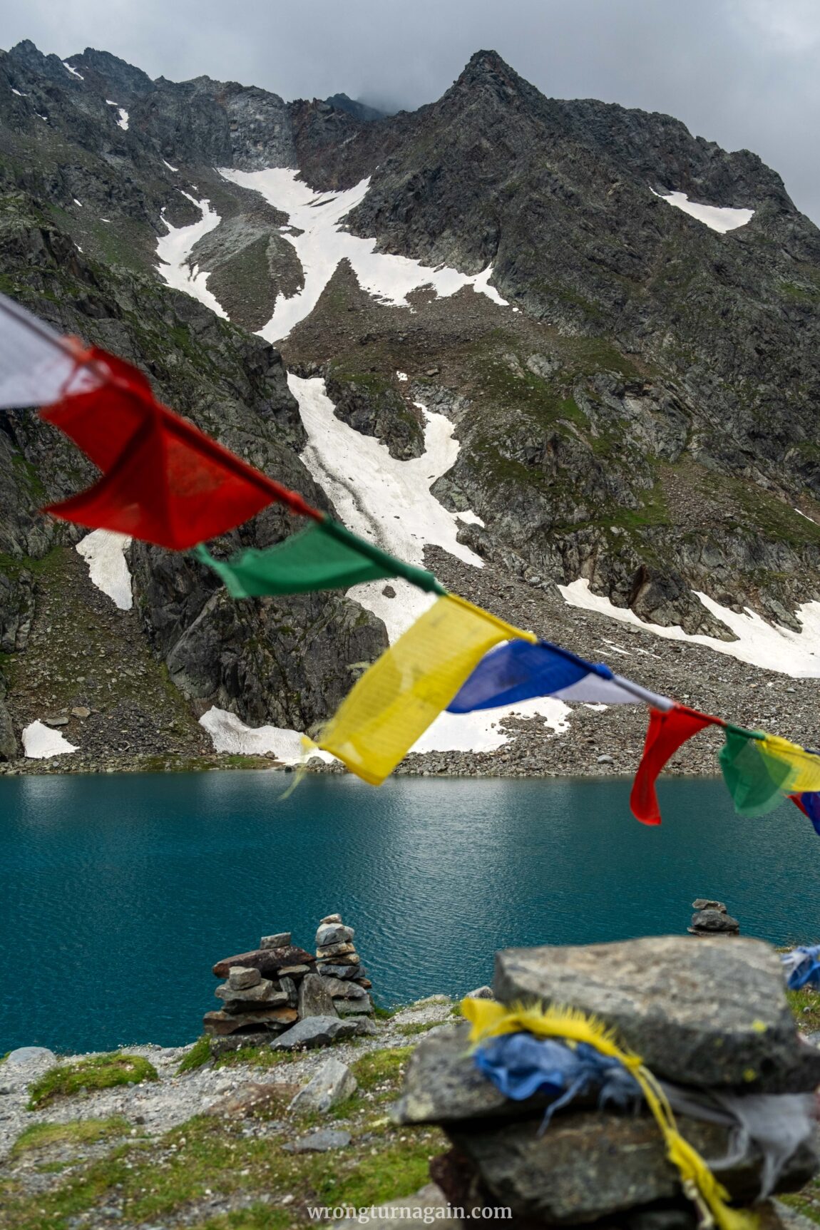
Upon arrival, you’re greeted by a visual symphony: tranquil azure waters (as the name “Blue Lake” suggests), surrounded by granite boulders and alpine vegetation. Adding to the mystical atmosphere are numerous stone cairns, known locally as Steinmännchen or Stoanmandl, and colorful Tibetan prayer flags. Take a moment to absorb this serene setting before retracing your steps to the hut.

Geological Insight: Blaue Lacke and its neighbor, Grünausee, are prime examples of glacial lakes. How are they formed? As glaciers move, they push rocks and sediment, creating ridges of debris known as moraines. When the glacier melts, these moraines act as natural dams, blocking water flow and creating basins that fill with meltwater, forming lakes.
Add-On Adventure: Hike to Grünausee
If you have a couple of extra hours and are up for climbing 200 more meters, head back to the fork just before reaching the hut and take the path to the left this time to reach the Grünausee. Spanning nearly 50,000 sqm, it’s the largest mountain lake in the Stubai Valley. Once fed by the Kleiner Grünau glacier, which made the water cloudy with glacial milk, the now glacier-free lake is clear, showcasing stunning colors at an altitude of 2,335 meters.

Sulzenauhütte to Grünausee (one-way): Distance: 2.3km || Time: 1h || Ascent: 250m || Descent: 45m
Section V – Returning to the Trailhead
To begin your return journey, retrace your steps back down to the Sulzenaualm meadow. Approximately 1km into the descent, you’ll reach a junction where you can take an alternative path compared to your ascent route. This option, turning right, brings you closer to the waterfall before eventually merging with the main trail.
Once you reach the meadow, continue until you arrive at the next junction (location). We recommend following the same route back to the trailhead via the Wilde Wasser Weg, as this proved the more scenic and direct option. However, if you prefer a different route, you can take the path to your left this time.
This alternative route features more switchbacks, gradually losing elevation as it approaches the Sulzbach stream. The trail begins as a relatively level, rocky but navigable path, leading you into the valley. Further down, it transitions to a more rugged forest trail with additional switchbacks. Eventually, the path turns right, guiding you across the Ruetz stream (Ruetzbach) via the familiar bridge back to the Grawa Alm trailhead.

How to Get to the Sulzenauhütte Trailhead
Your hike begins at the magnificent Grawa Waterfall, one of the most impressive natural wonders in the Stubai Valley. The trailhead can be reached from the Tyrolean capital of Innsbruck via public transportation or private vehicle. It is also accessible from Italy, but only by car.
By Train & Bus
Start your journey by making your way to the Innsbruck train station (Bahnhof), which offers excellent connections throughout the country. If traveling from Munich, you can arrive either by train or by Flixbus, the latter of which drops you off approximately 600m (8-minute walk) from the train station (drop-off location).
Once at the Innsbruck Bahnhof, head to the bus stand outside and look for Regional Bus #590 bound for Neustift i. St. Stubaier Gletscher. Your stop is “Grawa Alm”, about four stops before the final destination. This bus journey takes roughly 1 hour and 10 minutes, with departures every 30 minutes.

Tickets: You can find timetables and purchase tickets online (final stop: Neustift i. St. Grawa Alm). Alternatively, a one-way bus ticket from Innsbruck can be bought from the driver for €13.00 (cash only).
Tip: For two or more travelers, consider the 2Plus Day Ticket at €38.30, granting unlimited Tyrol regional transportation for 2 adults and up to 3 children for the entire day.
By Car
Driving from Innsbruck or Italy, set your destination as the Grawa Alm Parking. Keep in mind that you’ll be using a motorway, so make sure to have a Vignette (toll sticker).
From Innsbruck, take the A13 motorway towards Brenner, heading south into Italy. You’ll cross the Europabrücke, which requires a €3.50 toll. To avoid this, follow the B182 instead, which adds about 15 minutes to the drive. Exit at Schönberg, the first exit after the toll station, and follow the signs for Stubaital. Continue on the Stubaitalstraße (B183) for approximately 24 kilometers until you reach the Grawa Waterfall parking area.
Traveling from Italy (Brenner Pass), take the A13 motorway north towards Innsbruck. Exit at Schönberg and follow the signs for Stubaital, then continue on the B183 Stubaitalstraße to the Grawa Alm parking.

Parking: The Grawa Alm car park is conveniently located next to the bus stop and is free for hikers. If this lot is full, you can park at the Sulzenauhütte Parking, a short distance up the road.

Where to Eat During your Hike
During your hike, you’ll encounter three traditional alpine spots where you can savor hearty mountain cuisine while taking in stunning views. These eateries are conveniently located at various points along your route: the Grawa Alm at the trailhead, the Sulzenau Alm midway, and the Sulzenauhütte at the hike’s end.

Did you know? In the Austrian Alps, an “Alm” and a “Hütte” serve different purposes. An Alm is a summer mountain pasture for grazing cattle, often featuring a simple establishment offering local dairy products and basic accommodations. A Hütte, on the other hand, is a mountain hut or lodge primarily catering to hikers and climbers with more extensive facilities and services.
- Grawa Alm: This charming hut marks the beginning of your adventure. Its terrace offers a spectacular view of the Grawa waterfall, while the interior exudes traditional Alpine warmth. Savor a cold beer with a view or indulge in Tyrolean classics like Grandma’s Kaiserschmarrn (scrambled pancakes).
- Sulzenau Alm: Nestled in an expansive meadow plateau, this pasture hut is surrounded by waterfalls, streams, and grazing sheep. It’s the perfect spot to rest and soak in the natural beauty. A distinctive feature is its handmade chairs carved into various figures. Open from early July to early September, Wednesday through Sunday.
- Sulzenauhütte: A popular overnight stop for Stubai High Trail hikers, this mountain hut boasts a sun-drenched terrace ideal for concluding your day’s trek. The kitchen prides itself on using local produce to create delicious seasonal and daily menus. Sulzenauhütte has earned the “Stubaier Genussbetrieb” award, recognizing it as a mountain restaurant of excellence embodying Stubai’s culinary heritage.

Tip: Carry sufficient cash with you, as most mountain huts have no card payment facilities.

Where to Stay in the Stubaital
The picturesque village of Neustift im Stubaital serves as the valley’s main hub. This traditional ski and mountaineering resort attracts winter sports enthusiasts for the Stubai Glacier and the Elfer skiing area, while hikers use it as a gateway to the 120km Stubaier Höhenweg. Neustift offers a wide range of accommodation and dining options to suit various preferences and budgets.
For those seeking a quieter retreat, consider the charming hamlets of Falbeson or Ranalt, both part of the Neustift im Stubaital municipality. While accommodation options are more limited here, these serene locations offer a peaceful escape and are conveniently close to your trailhead at the Grawa Waterfall.

Accommodation in Stubaital: Gletscher-Chalet Stubai, Ranalt ~ Kartnall´s Alm, Falbeson ~ Donneralm, Falbeson ~ Premium Activehotel Bergkönig, Neustift i. St. ~ Alpeiner – Nature Resort Tirol, Neustift i. St.
The Stubai Cards (Super/Guest)
When staying in the Stubai Valley, you’ll receive the Stubai Guest Card from your accommodation, granting free parking and access to hiking and e-bike tours. For visits between May 17 to November 3, 2024, an additional card offers complimentary use of all four Stubai cable cars, select public transport, and a 30% discount on attractions.
This enhanced card is either provided free of charge if your accommodation participates in the program (Stubai Super Card) or can be purchased separately (Stubai Card) for €92 for adults and €46 for children up to 14 if your lodging isn’t a participating business.
Mountain Hut Experience
For those looking to extend their alpine adventure or explore part of the Stubai High Trail (Stubaier Höhenweg), the Sulzenauhütte offers an excellent overnight option. The hut features varied accommodations: one double room, eight shared rooms (Zimmerlager / Mehrbettzimmer) with 4-6 beds, and larger dormitories (Matrazenlager) with 60 spaces.

Booking: Reservations can be made online. Prices vary based on room type, age, Alpine Club membership status, and chosen dining options. Non-Alpine Club members must book a stay with half board, priced at €45 per person per night. Note that payment is cash only.
Tip for Frequent Hikers: If you plan to visit multiple huts in the Austrian Alps, consider joining an Alpine Club like Alpenverein Austria for significant savings on accommodation.

When to Hike to the Sulzenauhütte
The Sulzenauhütte, at 2,191 meters, is best visited between late June and early September when the snow has melted and trails are fully accessible. Even this time, however, be prepared for occasional summer rain.
To enjoy the hut experience, plan your hike during their operating seasons. Sulzenau Alm is open from early July to early September, and Sulzenauhütte from mid-June to late September. Note that the Sulzenau Alm is only open from Wednesday to Sunday. The Grawa Alm, thanks to its accessible location at the trailhead, is open nearly year-round.
Tyrol, Austria
Travel and Hiking Guides
MOUNTAIN LAKES
● Lake Gufelsee in the Lechtal Alps: from Hanauer Hütte
● Zillergründl Reservoir in Zillertal: to Plauener Hütte and Klein Tibet
● Olpererhütte & Suspension Bridge in Zillertal
● Seebensee & Drachensee Lakes in Ehrwald
● Lake Salfeiner See & Grieskogel around Innsbruck
● Hirschebensee & Plenderlessee in Kühtai
GORGES
● Wolfsklamm Gorge near Innsbruck
● Tiefenbachklamm in Alpbachtal
● Kaiserklamm in Alpbachtal
● Rosengartenschlucht in Lechtal
VILLAGE TRAVEL GUIDES
● 9 Best Things to Do in Kramsach
● The Best Things To Do In Alpbach